Bible Maps: Key Journeys & Geography
These four maps are drawn on real terrain — actual coastlines, mountains, deserts, and modern place names — with the biblical routes, cities, and territories plotted on top at their real latitude and longitude. Where scholars dispute a location itself — the Exodus route above all — both proposed options are shown rather than one being picked for you.
The Exodus: Two Proposed Routes
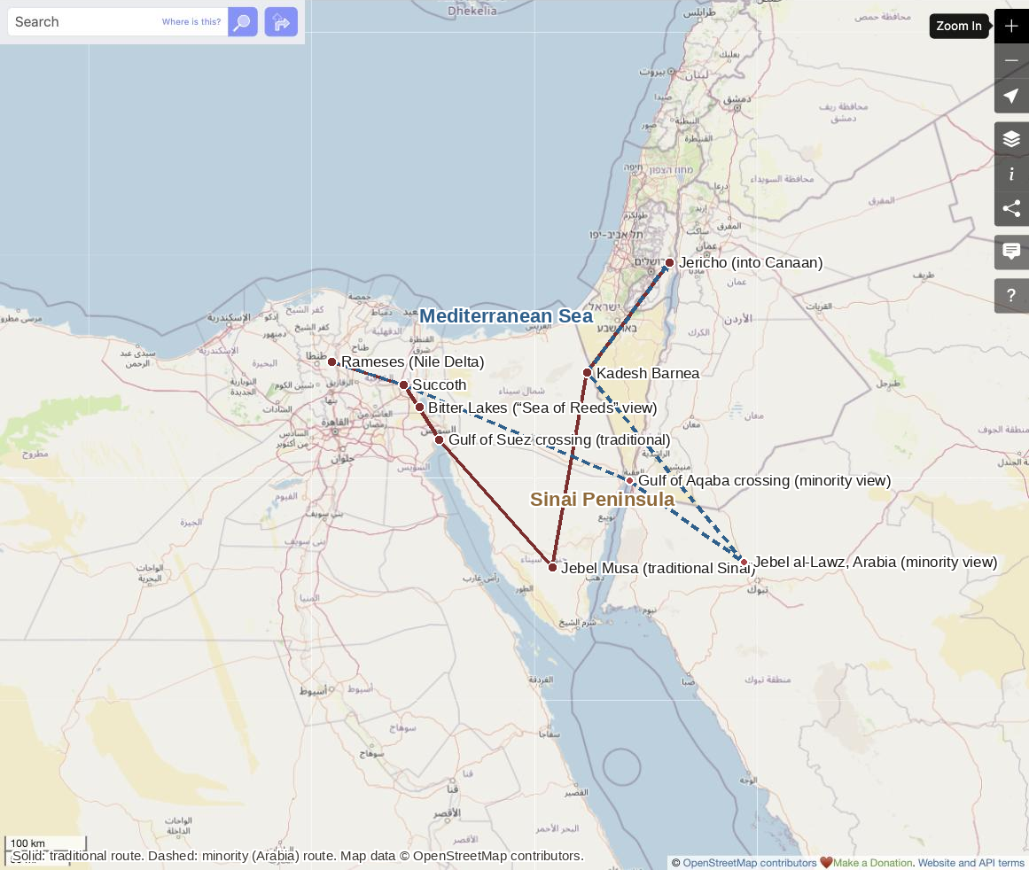
Solid line: traditional route (Gulf of Suez, Jebel Musa). Dashed line: minority route (Gulf of Aqaba, Jebel al-Lawz). Base map © OpenStreetMap contributors.
Every element of this map beyond the biblical text itself — the route, the crossing point, and the location of Mount Sinai — is disputed to some degree. The traditional route (solid line) crosses near the Gulf of Suez and identifies Mount Sinai with Jebel Musa in the southern Sinai Peninsula, an identification going back to Byzantine Christian tradition and the founding of St. Catherine's Monastery there in the 6th century, but with no direct textual proof connecting that mountain to the biblical Sinai. A significant complication sits at the very first step: the Hebrew text says the crossing was at the yam suph, literally the “Sea of Reeds,” which many scholars think refers to a marshy lake near the Bitter Lakes on the Isthmus of Suez rather than the Red Sea proper — a translation choice with real consequences for where the whole route is drawn. A minority view (dashed line), citing Galatians 4:25 and Paul's own placement of Sinai “in Arabia,” instead locates Mount Sinai at Jebel al-Lawz in modern Saudi Arabia, crossing the Gulf of Aqaba rather than the Gulf of Suez; this view has little support among mainstream biblical archaeologists but continues to circulate. Separately, and more fundamentally, some biblical archaeologists question whether a mass Exodus of the scale described in the text is archaeologically supported at all — a broader dispute covered on the biblical history timeline.
The Divided Kingdom: Israel & Judah
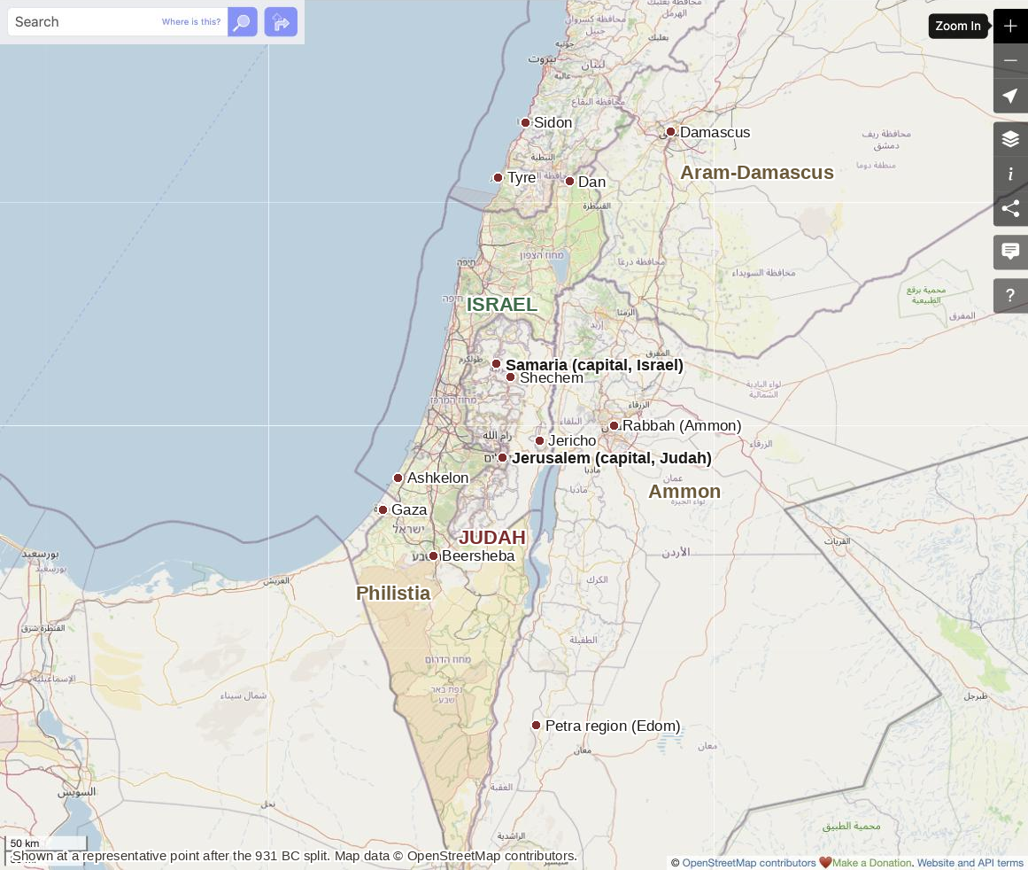
Shown at a representative point after the 931 BC split, not one fixed year. Base map © OpenStreetMap contributors.
The kingdom split after Solomon's death (traditionally 931 BC), with the ten northern tribes under Jeroboam I forming Israel (capital eventually Samaria) and Judah and Benjamin remaining under Rehoboam, David's grandson, with its capital at Jerusalem. Israel fell to Assyria in 722 BC; Judah survived until Babylon destroyed Jerusalem in 586 BC. How large and centralized either kingdom really was in its earliest years — especially the extent of the united monarchy under David and Solomon that preceded the split — is itself disputed among archaeologists, covered in more depth on the biblical history timeline; this map shows the kingdoms at a representative later point in their history, not a single fixed year.
Second Temple Judea & Galilee
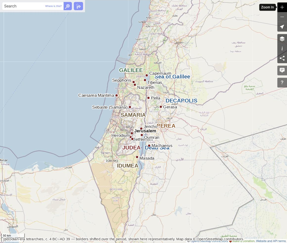
Shown at a representative point in the Herodian era (c. 4 BC–AD 39); tetrarchy borders shifted over the period. Base map © OpenStreetMap contributors.
After Herod the Great died in 4 BC, Rome split his kingdom among three sons rather than letting one inherit it whole: Herod Antipas received Galilee and Perea (the two territories he ruled throughout Jesus's ministry, and the reason Jesus and John the Baptist both operated mostly within a single tetrarch's domain); Philip received the northeastern territories around Caesarea Philippi; and Archelaus received Judea, Samaria, and Idumea, but ruled so badly that Rome deposed him in AD 6 and folded his territory into a Roman province governed directly by prefects — Pontius Pilate among them. The Decapolis, shown here as a loose region, was not a Jewish territory at all but a set of largely self-governing Hellenistic Greek cities with their own civic institutions, interspersed among Jewish Galilee and Perea rather than cleanly separated from them — a reminder that these boundaries were administrative and cultural, not the hard borders a modern map implies. Qumran, near the Dead Sea, is the site where the Dead Sea Scrolls were discovered starting in 1947; scholars broadly agree the scrolls are Second Temple Jewish texts, but who lived there and wrote them — most commonly identified with the Essenes, though this identification itself has critics — remains debated, and the scrolls themselves are central to the manuscript evidence discussed on textual criticism. See also the nature of Jesus for how this same geography and timeframe bear on the Gospels.
Paul's Four Journeys
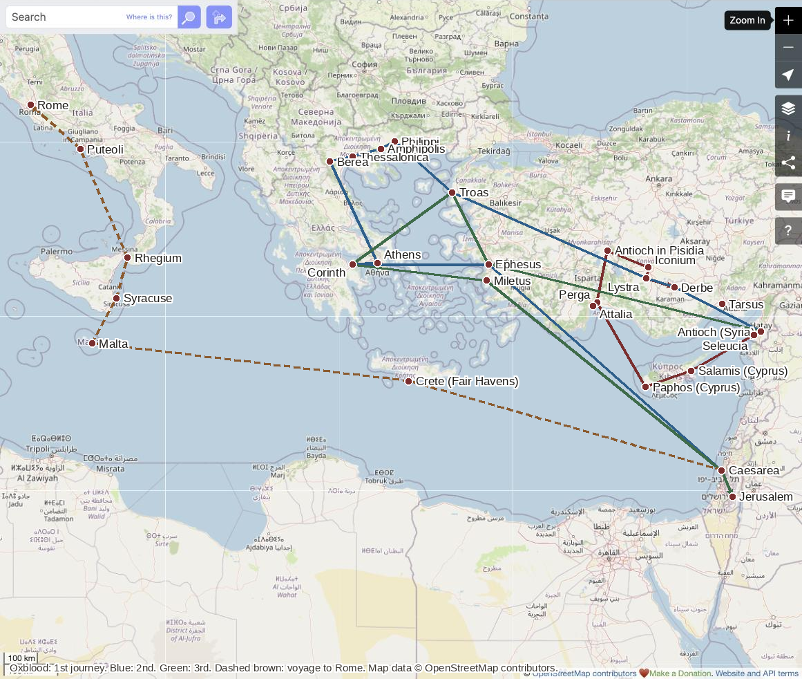
Oxblood: 1st journey (Acts 13–14). Blue: 2nd journey (Acts 15:36–18:22). Green: 3rd journey (Acts 18:23–21:17). Dashed brown: voyage to Rome as a prisoner (Acts 27:1–28:16). Base map © OpenStreetMap contributors.
The four routes shown — drawn from Acts 13–14, 15:36–18:22, 18:23–21:17, and 27:1–28:16 — are simplified to their major waypoints; Acts itself records additional stops (Neapolis, Cenchreae, Assos, Cos, Rhodes, Patara, Tyre, and others) left off here for legibility. Exact dates for the journeys are debated and depend partly on unresolved questions about Paul's own chronology (including how it lines up with the Jerusalem council of Acts 15), but the relative sequence and geography shown here are not seriously disputed.
Sources & Further Reading
- Exodus 12–19; Numbers 33 (the Exodus itinerary)
- Galatians 4:25 (Paul's placement of Sinai “in Arabia”)
- 1 Kings 12; 2 Kings 17; 2 Kings 25 (the kingdom's division and falls)
- Acts 13–14; 15:36–18:22; 18:23–21:17; 27:1–28:16 (Paul's journeys)
- Josephus, Antiquities of the Jews and The Jewish War (Herod's kingdom and its division)
- James K. Hoffmeier, Ancient Israel in Sinai (2005)
- Sean Freyne, Galilee, Jesus and the Gospels (1988)
- The HarperCollins Atlas of Bible History